Abandoned Bunkers of Salpalinja, Finland
2 min read
In the early 1940s, tensions were high in Finland, as locals suspected that the Soviet Union, not satisfied with the territorial gains they had made during the Winter War (1939–1940), would plan another invasion..
As a result, in 1940, Finland began the construction of so-called Salpalinja (the “Salpa Line”), a system of more than 700 field fortifications made from concrete or excavated from rock along country’s eastern border.
Stretching 1,200 kilometers from the Gulf of Finland in the south to modern-day Pechengsky, Russia, in the north, Salpalinja consisted of bunkers, trenches, fueling stations, weapons depots, and more.
The line incorporated many lakes and marshes into its terrain, as these areas could be tough to navigate and easy to defend.
Completed in 1944, Salpalinja was a huge project set to defend Finland against a possible Soviet invasion. However, that invasion never came.

Now Salpalinja sees more action from tour groups and urban explorers than it ever did in combat.
Many of the features of the line still stand today, as they never endured any of the devastations of war. Along the line are multiple museums dedicated to its past and its bunkers, as well as tours that provide an interesting and detailed overview of its history.
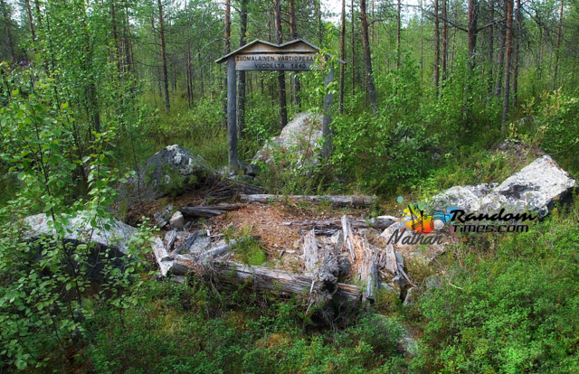
However, many bunkers and dugouts are buried deep in the forests, away from guided tours and regular tourists. These areas offer great experiences for those interested in a different or additional perspective from the various museums. The Ventovuori area in Virolahti offers numerous bunkers and systems to explore despite it is just a very small part of Salpalinja, that was painstakingly built in the name of preparedness and defense, but remains only as a reminder of a history that never was, but it could have been.
Author’s notes: the line’s southern part was the most strongly fortified. The Salpa Line can be explored by following the South-East Salpa trail, which is a 50km one-way hiking route in Virolahti and Miehikkälä. There are points of interest suitable for everyone, from formal museums accessible roadside features, to hidden fortifications for the adventurous traveller, found off the beaten path. These coordinates 60.5267, 27.5461 are a good place to park. The winding paths are often overgrown, but will lead to multiple bunkers, filling stations, caves, dugouts, and other abandoned or collapsed structures. The bunkers are very very dark. Be sure to bring strong flashlights.


